Longhorn Army Ammunition Plant
Environmental Restoration Program
LHAAP-50
Site Description/History
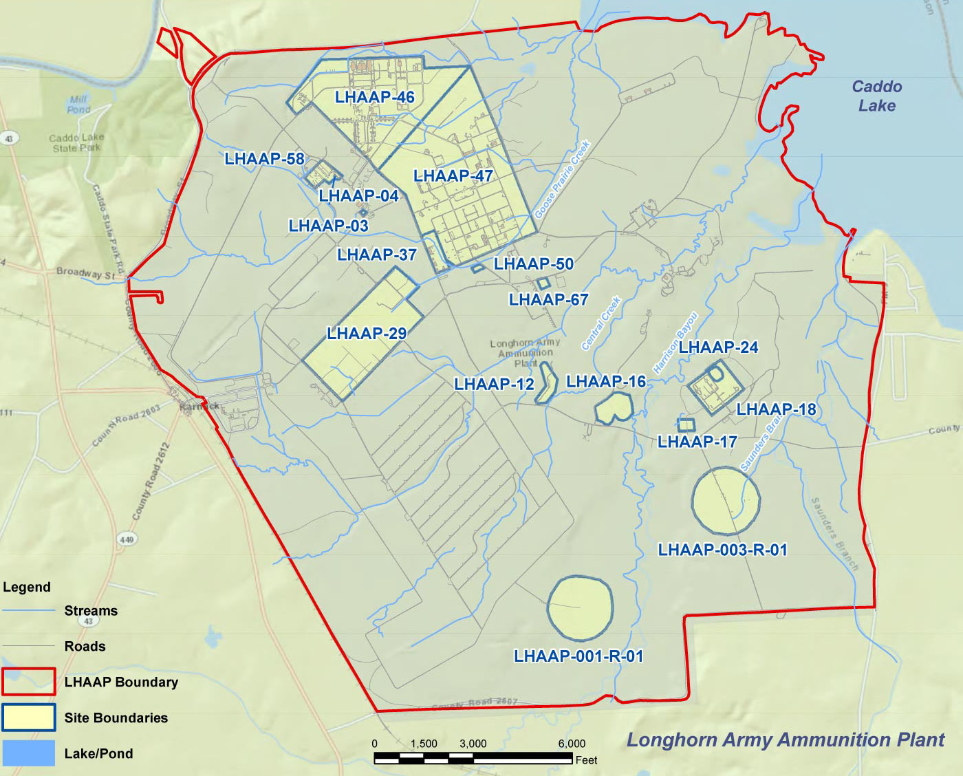
The LHAAP-50 site (former sump water tank) is in the north-central portion of LHAAP and covers an area of approximately 1 acre. The northeastern half of the LHAAP-50 is an open area of grass and brush that is bounded by South Crocket Avenue to the northeast, a drainage ditch to the west, a railroad spur to the south, and Goose Prairie Creek to the north. Runoff from the northeastern half of the site is generally toward the northeast. Runoff is collected by a drainage ditch to the northeast that runs parallel to South Crockett Avenue and eventually joins Goose Prairie Creek. Runoff from the southwestern portion of the site is collected to the west by a drainage ditch that carries the runoff north into Goose Prairie Creek, which eventually empties into Caddo Lake.
LHAAP-50 contained a 47,000-gallon capacity aboveground storage tank ( AST), which received industrial wastewater from various industrial waste production sumps throughout LHAAP from 1955 to 1988. After the solids were filtered, the storage tank contents were discharged up stream of the bridge on Crockett Avenue, south of 51st Street into Goose Prairie Creek. The flow in the creek was sufficient to dilute the water to safe levels. If natural flow in the creek was considered insufficient, clean water was apparently pumped into the creek to dilute the contents. The AST has been removed.
Remediation Activities
Between 1992 and 2010, numerous investigations were conducted in a phased approach to determine the nature and extent of contamination at LHAAP-50. Beginning in 1995, an initial site investigation was conducted at LHAAP-50 where sediments and soils were sampled to assess whether industrial wastewater that had been stored in the AST had impacted the site. Phase II and III investigations were conducted that included the collection of soil, sediment, surface water, and groundwater samples. Additional investigations were conducted, including the installation of several wells and soil borings from 2000 through 2002, a site assessment in 2003, and further sampling from 2004 through 2010, to determine the nature and extent of contamination at LHAAP-50. Media investigated included soil, sediment, surface water, and groundwater.
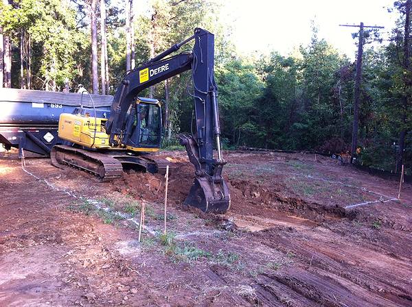
The remedy for this site was implemented in 2013 and included monitored natural attenuation ( MNA) of groundwater, excavation and off-site disposal of perchlorate-contaminated soil, and a groundwater use restriction Land Use Control ( LUC). Excavation and off-site disposal of approximately 183 cubic yards of perchlorate-contaminated soil was conducted in September 2013. Following the removal of the contaminated soil, composite soil samples were taken from the floor and sidewalls of the excavation to confirm that all contamination had been removed.
Remedial Action Operation ( RA-O) groundwater monitoring was performed for 3 years; however the 3rd Annual RA-O Report in 2018 concluded that geochemical conditions were not optimal for MNA and the plume had expanded beyond its baseline footprint. An Explanation of Significant Differences ( ESD) to implement a contingency remedy consisting of in situ bioremediation ( ISB) was signed by EPA in August 2019. A Remedial Design/Remedial Acton Work Plan ( RD/ RAWP) for the contingency remedy was completed in March 2019 and ISB was completed in December 2019. A Remedial Action Completion Report ( RACR) was completed in November 2020.
Contaminants of Concern
Perchlorate, PCE, TCE, 1,1- DCE, 1,2- DCA, cis-1,2- DCE, and VC in Groundwater.
Perchlorate in Soil.
Current Phase
Post-ISB Remedial Action Operation ( RA-O) groundwater monitoring is continuing.
Future Phase
Site Closeout
Sites Links
LHAAP Map
LHAAP-50 Documents
- LHAAP-50 Record of Decision
- LHAAP-50 Remedial Design
- Final LHAAP-50 ESD
- LHAAP-50 RD/RAWP Contingency Remedy
- LHAAP-50 Draft Final RACR
Photos